Martha’s Vineyard may not look like “fire country” to many—but the latest risk maps, historical fire data, and expert analysis tell another story. Wildfire risk here is real, growing, and shaped by the Island’s ecology, climate trends, and how we manage land and prepare our towns. The good news: the Dukes County Community Wildfire Protection Plan gives us a road map for reducing that risk. Here’s what’s at stake—and what we can do.
What Drives Wildfire Risk on MV
The Dukes County Community Wildfire Protection Plan (CWPP), developed with local fire chiefs, conservationists, tribal stakeholders, and state agencies, identifies several key risk factors specific to our Island.
| Category | Key Features on MV | Why It Matters |
| Vegetation & “Fuel” Types | Large tracts with scrub oak, pitch pine, heathland; dense mixed woodland; coastal shrublands; open scrub oak. | These plants burn easily. Scrub oak + pitch pine especially contribute to rapid fire spread and intense flames. |
| Soils & Ecological Region | The Island is part of the Atlantic Coastal Pine Barrens—with sandy, acidic, very porous soil that drains quickly and dries out in dry spells. | Dry soils plus flammable understory make ignition more likely, especially in drought or low humid conditions. |
| Weather & Climate Trends | Long dry periods in summer; projected increases in drought, longer gaps between rainfall; risk of higher winds. | Dry fuels + wind = faster fire spread and harder firefighting. Climate change is expected to increase these “fire danger days” significantly. |
| Human Factors & Ignitions | Many fires are started by humans: debris burning, accidental, or from development; proximity of homes and infrastructure to flammable vegetation. | Human activity increases ignition points; areas where homes border wildland are more vulnerable. Poor defensible space, narrow/difficult roads, etc., raise the stakes. |
| Topography & Access | Dirt roads or narrow roads, limited access or turnouts for fire apparatus; some lots or parcels far from fire stations. | Delays in response increase damage and risk. Also, in case of evacuation or property protection, access is essential. |
According to the plan, all six towns on the Vineyard are assessed as high risk, but some towns with more forested, interior, or scrub-vegetation land (Edgartown, West Tisbury, Chilmark) show larger proportions of extreme risk.
Also, though large-scale forest fires are rare (last major forest fire was in 1967), smaller brush fires have increased sharply, especially in recent years.
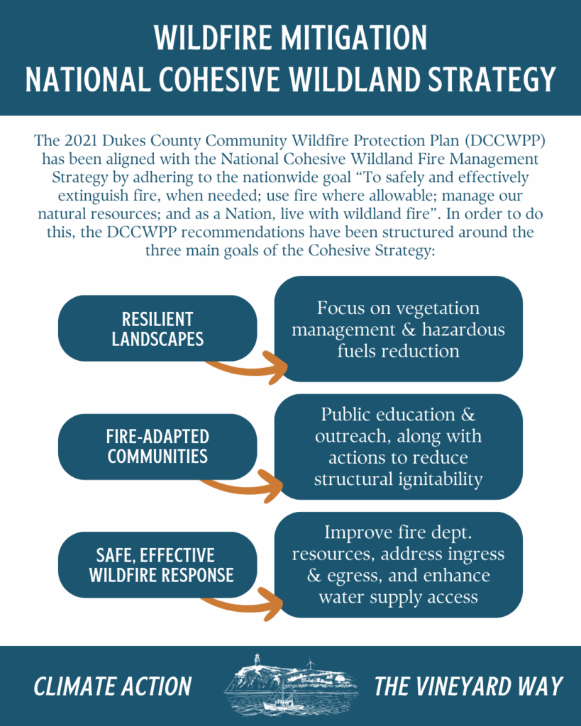
What the CWPP Recommends (Risk Mitigation Strategies)
The CWPP doesn’t just diagnose; it outlines concrete steps to reduce risk, enhance preparedness, and ensure the Island can respond when fires threaten. Here are major strategies:
- Fuel Management & Landscape Restoration
- Prescribed burns in key locations, such as the state forest, to reduce buildup of flammable vegetation.
- Mechanical removal of overgrowth and ladder fuels (low branches, dense understory) especially along roads, around homes, and in high risk areas.
- Creation of firebreaks, which are cleared or low-fuel strips that help slow or halt spread of fire.
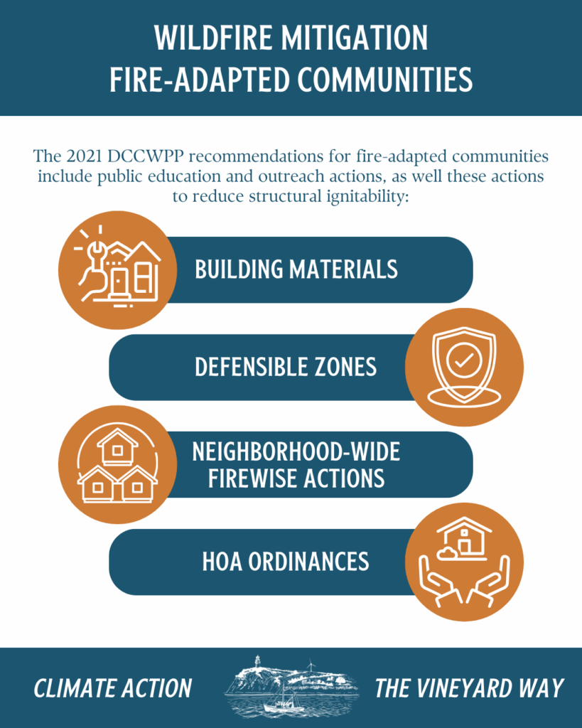
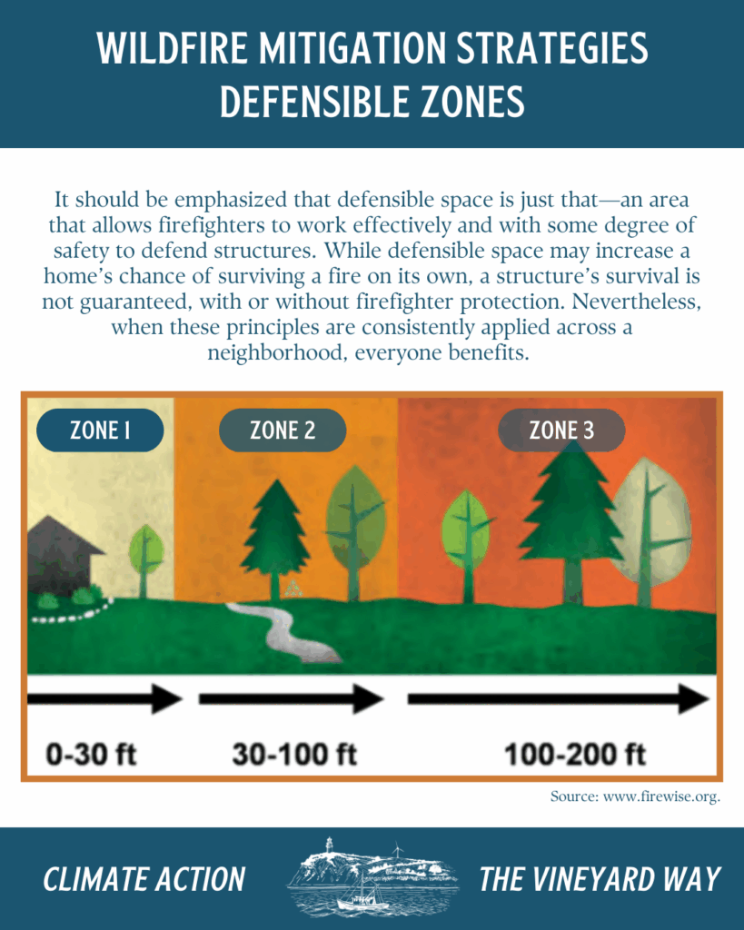
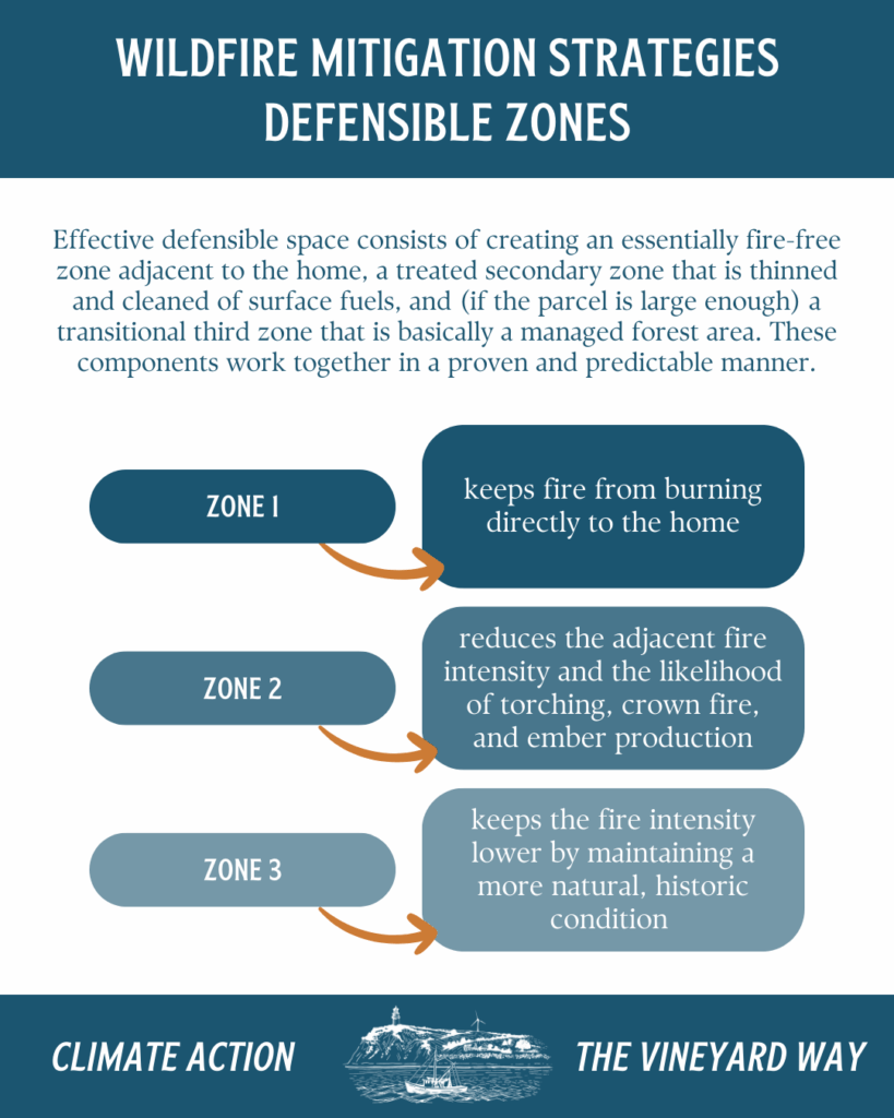
- Reducing Structural Ignitability & Defensible Space
- Guidelines for landowners to keep vegetation trimmed near houses, maintain lower fuel loads adjacent to structures. Zone rules like “Structure Ignition Zone” (0-30 feet), “Firebreak Zone” (30-100 ft), etc.
- Building codes / property design that reduce flammability such as use of fire-resistant materials, clearing near roofs, chimneys etc.
- Public education & outreach, including teaching folks how to maintain defensible space, reduce ignition risk, avoid risky human behaviors (such as debris burning in dry times).
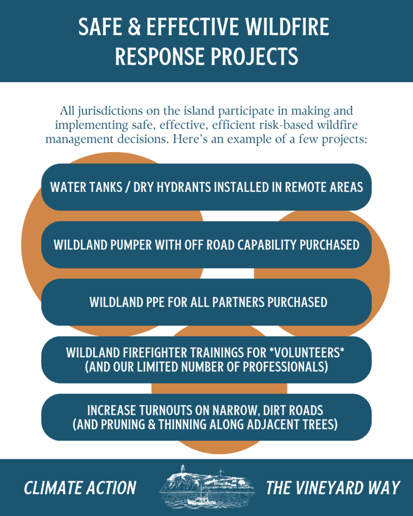
- Improving Fire Response Capacity
- Ensuring fire departments have the equipment, training, staffing to respond quickly. Examples include better tools for fuel management (mulchers, excavators), and better water access (hydrants, dry hydrants) in places where water is limited.
- Enhancing access routes, including improving or widening roads, ensuring ample turnouts (places for fire trucks to turn or pass), addressing steep or blocked roads.
- Geographic and procedural preparedness, including mapping high risk zones, planning evacuations, bolstering monitoring (lookouts, patrols, early detection), and mutual aid between fire departments.
- Restoring & Maintaining Vegetation Communities
- Using grazing, mowing, or controlled burns in certain ecosystems (like sandplain grasslands or scrub oak areas) to reduce fuel loads while preserving habitat.
- Controlling invasive species that may alter fuel dynamics.
What’s Being Done & What You Can See
Since the release of the CWPP, several implementation actions are already underway on Martha’s Vineyard. Some of these include:
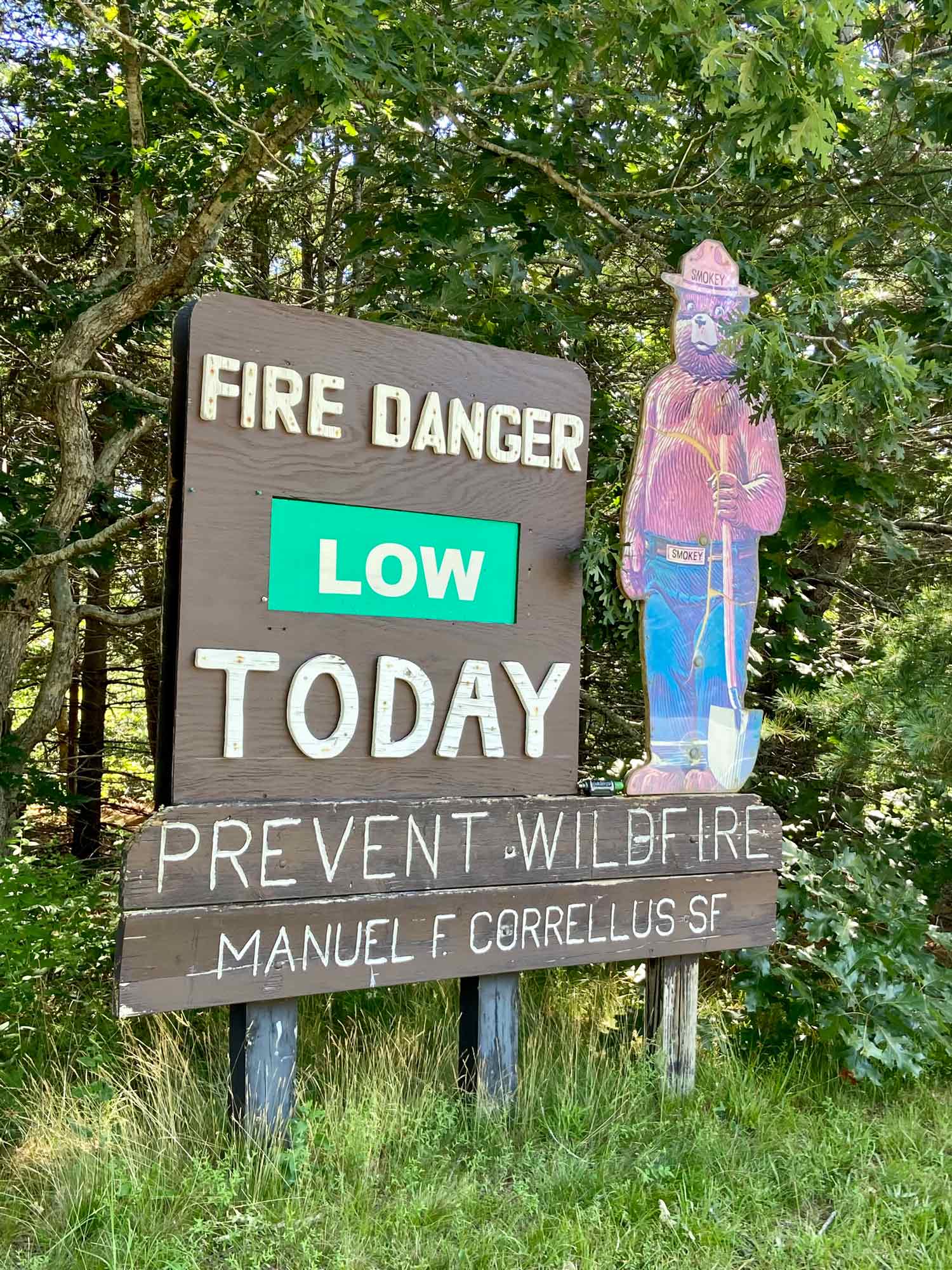
- Controlled burns in Manuel F. Correllus State Forest (58 acres) and several burns on land managed by The Nature Conservancy & The Trustees.
- GIS assessments to find land well-suited for future burns or fuel reduction.
- Equipment upgrades (e.g. an excavator with a mulching head) for fuel removal.
- Installations of dry hydrants in strategic locations to aid firefighting.
- Community‐level efforts: Firewise programs, homeowner outreach on defensible space, posting visible house numbers.
Challenges & What Needs More Attention
While progress is real, the plan also flags barriers:
- Financing & Resources: Controlled burns, large fuel-breaks, equipment upgrades are expensive and require coordination.
- Public buy-in & permitting: Some mitigation strategies (especially burns) require clear communication with town boards, neighborhood residents, and regulatory bodies.
- Access issues: Particularly in remote or densely vegetated areas; roads that are too narrow or have overhanging canopies; difficulty for large fire vehicles.
- Climate change acting synergistically: Hotter, drier conditions, more frequent drought, increasing “fire danger days” will compound risk. Without mitigation, what was once rare may become more threatening.
What You (as a Resident) Can Do Now
Because wildfire protection isn’t just about big agencies—it also depends heavily on what property-owners, neighbors, town boards, and everyday people do. Some actionable steps:
- Create and maintain defensible space around your home: clear flammable shrubs, keep branches trimmed, remove ladder fuels.
- Keep your property well-marked and accessible (house numbers, clear driveways, cleared edges of roads).
- Be careful about ignition sources: avoid burning debris in dry periods, manage outdoor fire safely.
- Know your escape routes / plan: especially if you live in / near high risk zones.
- Support or volunteer with local fuel reduction programs, Firewise community efforts, or habitat work that reduces fire fuel.
- Attend public meetings, engage with the CWPP process locally to advocate for needed fire breaks, better road maintenance, water access, etc.
Why It Matters & Looking Ahead
Wildfire risk may seem like something happening elsewhere—but on Martha’s Vineyard it’s intertwined with our unique ecology, climate change, land use policies, and community preparedness.
If the mitigation strategies in the CWPP are fully implemented, we stand to gain:
- Safer neighborhoods and homes
- Reduced risk of large destructive fires
- More resilient natural systems and less loss of habitat
- Better coordination among fire services and communities
Ultimately, being a fire-adapted community means recognizing that wildfire risk is part of our landscape, but not accepting that we’re powerless.
Further Reading
- Community Wildfire Protection Plan Story Map
- Dukes County Community Wildfire Protection Plan
- SWCA’s Martha’s Vineyard Wildfire Protection Plan Report
- Report Shows Dukes County at High Risk for Wildfire
- Wildfire Plan Aims to Increase Awareness