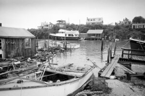
As climate change accelerates, Martha’s Vineyard is already experiencing the impacts of sea level rise, stronger storms, and more frequent flooding. To respond to these growing risks, the Martha’s Vineyard Commission (MVC) is working closely with town governments to update local floodplain and wetlands bylaws—key tools for protecting both public safety and the island’s natural resilience.
Why Do These Bylaws Matter?
Our current development regulations are based on outdated assumptions and FEMA flood maps that reflect past conditions—not the worsening storm surges and future sea levels we now face. Here’s why the updates are needed:
🌊 Sea level rise and intense storms are expanding the true flood zone far beyond current FEMA designations.
🏘️ Development in flood-prone areas must consider future flood risks, not just historical data.
🛡️ Model bylaws are now available to help towns proactively address these concerns.
🧭 The goal? Protect human safety through updated Floodplain Bylaws and safeguard the natural areas that absorb floodwaters via enhanced Wetlands Bylaws.
Community Collaboration in Action
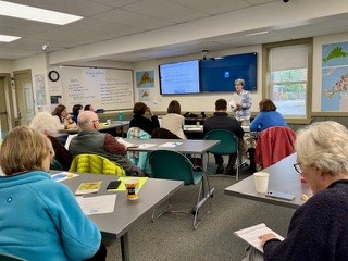
On Saturday, April 5, MVC hosted a workshop for town officials and committee members to dig into the model bylaws and the mapping tools available to support this work. Key presenters included:
- Shannon Hulst, Barnstable County Floodplain Specialist and co-author of the model bylaws
- Chris Seidel, MVC Cartographer and GIS Coordinator
The event was attended by representatives from Planning Boards, Conservation Commissions, and Climate Committees from across the island—laying the groundwork for an island-wide commitment to smarter, safer floodplain management.
What’s Next?
The goal is to finalize and adopt updated bylaws across Vineyard towns at the 2026 Annual Town Meetings. With clear guidance and collaboration already underway, the island is taking meaningful steps toward a more resilient future.